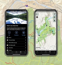
Parks Explorer App
There’s More to Explore!
The New York State Parks Explorer app is your key to helpful information about the variety of destinations and adventures available across the Empire State's vast system of state parks and historic sites. The app is free and available in both Apple and Google Play stores. Enjoy quick access to park information, including directions, hours, fees and rates, trail maps, events, and helpful know-before-you-go details. Download the app today and start exploring.
Key Features
- Search for parks and historic sites by location or amenities and sort results by distance to find places that are closest to your current location.
- Scan your Empire Pass or Lifetime Liberty Pass to digitally add your pass to the app’s wallet for easier visitor entry.
- Discover new must-see locations with themed content categories.
- Want to spend the night? Tap the camping reservations link to check out lodging options and book a stay.
- Looking for info or swag? The info screen provides FAQs, details about gift cards, and a link to our merchandise shop.
Events
Enhance your experience and discover the variety of events and festivities taking place statewide.
- Search the event calendar by date range, area of the state, theme, or specific park, and sort the results by date or distance.
- With one tap, you can add the event to your calendar and get driving directions.
- Additional features include tap for phone or online registration.
Know Before You Go & Alerts
Stay in the know with park alerts, maps, and contact information.
- Check the Know Before You Go feature for useful information before traveling.
- Tap the heart icon to “favorite” a park or site and receive important notifications and alerts specific to that property.
- Quickly view the alerts for all your favorited properties in one location.

Mapping Tools
- The Explorer app includes mapping tools to assist you with helpful wayfinding information when in the parks and on the trails.
- Choose offline maps to download when connectivity could be a challenge. Choose live maps for use on Wi-Fi or with good connectivity.
- No cell service? No problem; when your device's location services are turned "on," you can easily follow along in real time where you are on the map.
- Live maps include information about trails, park features, and amenities by simply tapping on a trail or icon;
- Tap for trail segment distance;
- Change base layers in live maps from satellite view, simple street view, or topography.
- The app also includes a link to a brief video
 to demonstrate the latest mapping features.

